Map by the British Admiralty - Hydrographic Office, 1892, London

| Source identifier | Sylvia Ioannou Foundation collection M.0020 |
| Publication title(s) | Map by the British Admiralty - Hydrographic Office, 1892, London |
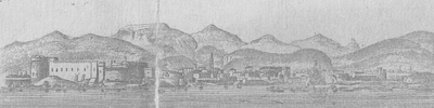
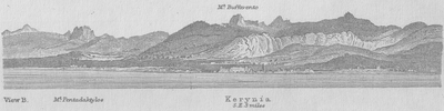
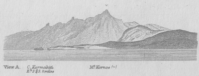
| Original cartouche, caption or heading | HYDROGRAPHIC OFFICE W.J.L.W. | Price Two & Sixpence | Mediterranean | [double rule] | Cyprus | The Coastline and Topography from a Survey made under the direction of | Captain H.H. Kitchener, R.E., 1882. | The Soundings by Captain Thomas Graves, H.M.S. Volage, 1849. | [key] // London._ Published at the Admiralty 24.th May 1892, under the Superintendence of Captain W.J.L.Wharton, R.N., F.R.S., Hydrographer. | Sold by J.D.Potter, Agent for the sale of the Admiralty Charts, 31 Poultry & 11 King St. Tower Hill. // Engraved by E. Weller // 2074 [with insets:] 'KERYNÍA' [plan of the harbour] [views, clockwise:] 'View A.' // 'View B.' - 'Kerynía' [2 views] // 'FAMAGUSTA FROM THE ANCHORAGE.' // 'View C' // 'View E' // 'View D' |
| Description | (Steel engraving, 650x960 mm.) This very interesting map is an example of the adaptation of elements from Kitchener’s map of Cyprus, published in 1885, to the nautical chart of Cyprus constructed by Graves and first issued in 1851. Graves’ chart contained very little information on the interior of the island. It was first published in this form by the Admiralty in 1892. A later edition appeared in 1913 with some changes in the insets. |
| Publication year | 1892 |
| Location published | London |
| Contributors | Potter, D., J. Kitchener, Herbert, Horatio, Captain Weller, E. Wharton, James, Lloyd, William, Captain Graves, Thomas, Captain |
| Belongs to collection | Sylvia Ioannou Foundation collection |
| Taxonomy | Map |
| Illustrations | |


How to cite this page
Source: https://gaia.hua.gr/en/coastal_cyprus/informationcarrier/6 (Retrieved: 05-11-2025)